Cape Cod: Articles: History, Places, Truro -- post an article
 The Water and the Rock
Before the Pilgrims laid their eyes and put their feet on historic Plymouth Rock, they drank their first New World water from what is now called Pilgrim Spring, in Truro.
To find these springs, they were “heartily glad,” and they drank with “much delight.” Local historians, after very careful search of the available records, are satisfied that the Pilgrim Springs are certainly those mentioned in Mourt’s Relation, a documentary account of the beginnings and doings of the Pilgrims. It was published in 1622.
To commemorate this event, and to protect the springs and make them more accessible to visitors interested in our nation’s early history, Pilgrim Spring State Park was established by the State of Massachusetts and later taken over by the Federal government in 1962 as part of the Cape Cod National Seashore.
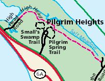
The territory is virgin land, and on it grow many of the identical kind of shrubs and flowers so welcomely seen by the first Pilgrims as they explored the area. Masses abound of wild roses, high-bush blueberries, bayberries, beach plums, and flaming samphire, a fiery-red low-growing March flower which the Pilgrims mentioned in their first accounts. The National Seashore’s Pilgrim Spring Trail is a short 3/4 mile hike from Route 6 in the Pilgrim Heights area of North Truro. The trail is well marked and you can walk the same land the Pilgrims did in 1620.
It was documented in the early 1950’s, before the State and then the National Seashore took over the land, that the spring no longer flowed:
However, the historic springs, like the historic Pilgrims, are no longer to be seen. It is believed that cessation of their flow was caused by the use of pipes that were introduced some time ago.
According to Arthur Wilson Tarbell’s Cape Cod Ahoy, the Pilgrim Spring was re-discovered and the land purchased in 1920 by a doctor from Boston.
• tell-a-friend • link to this post •
Map - (click marker for driving directions)view large maps: aerial, birdseye, street, satellite, hybrid, topo & aerial | view all mapped places
Comments:
No comments yet.Related Posts: are tagged with pilgrims, history, truro, places
- Pride of Provincetown
- Pilgrim Bill of Fare
- Gaynor & Dent Consignments South Dennis
- Brrrrrrrr!
- Lightning at Provincetown
<< 1955 Cape Fishing Report | A Fine Cleere Pond >>
Read More About Cape Cod


